
Топографическая карта Gulf Shores
Интерактивная карта
Нажмите на карту, чтобы отобразить высоту.
Об этой карте
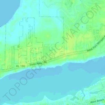
Название: Топографическая карта Gulf Shores, высота, рельеф.
Местонахождение: Gulf Shores, Baldwin County, Alabama, United States of America (30.25844 -87.71276 30.25998 -87.71125)
Средняя высота: 5 м
Минимальная высота: -3 м
Максимальная высота: 13 м
Jack Edwards National Airport is located in Gulf Shores and offers services from Gulf Air Center, Salt Air Aviation Center and Platium Air Center. The airport is located in town, two miles from the beach. Their FBO Gulf Air Center will provide a rental vehicle while they take care of fueling and storing aircraft. There is 48-hour and long term parking available. The longest paved runway extends 6,962 feet. The facility is at an elevation of 17 feet. They offer outside tiedown as well as hangar space for aircraft. They can provide space by the night, week or month.
Другие топографические карты
Нажмите на карту, чтобы просмотреть ее топографию, ее высоту и ее рельеф.
Gulf Shores
United States of America > Alabama > Gulf Shores
Gulf Shores, Baldwin County, Alabama, United States of America
Средняя высота: 6 м