
Сделать пожертвование
Топографическая карта Kohima
Нажмите на карту, чтобы отобразить высоту.
Сделать пожертвование
Kohima
Kohima (/koʊˈhiːmə/ ; Angami Naga: Kewhira (IPA: [ˈkɛʍɪɻə]) is the capital of the Indian state of Nagaland. With a resident population of almost 100,000, it is the second largest city in the state. Kohima constitutes both a district and a municipality. The municipality covers 20 km2 (7.7 sq mi). The city lies on the foothills of Japfü section of the Barail Range located south of the District (25°40′N 94°07′E / 25.67°N 94.12°E / 25.67; 94.12) and has an average elevation of 1,261 m (4,137 ft).
Сделать пожертвование
Об этой карте
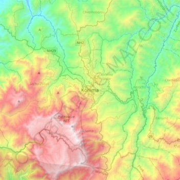
Название: Топографическая карта Kohima, высота, рельеф.
Местонахождение: Kohima, Kohima Sadar, Kohima, Nagaland, 797001, India (25.50188 93.94192 25.82188 94.26192)
Средняя высота: 1 425 м
Минимальная высота: 430 м
Максимальная высота: 2 993 м
Сделать пожертвование