
Топографическая карта Bull Shoals Lake
Интерактивная карта
Нажмите на карту, чтобы отобразить высоту.
Bull Shoals Lake
Bull Shoals Lake impounds the White River for the last time as water travels toward its mouth on the Mississippi River. Bull Shoals is thus the lake farthest downstream in a chain of four artificial lakes that include (from upstream to downstream) Beaver Lake, Table Rock Lake and Lake Taneycomo. The lake is controlled by the Army Corps of Engineers and has the primary purpose of flood control. The level of the lake fluctuates regularly with a normal pool level elevation of 654 feet above sea level, which is locally known as powerpool. However, the lake regularly fluctuates between an elevation of 630 to 680 feet. The upper part of the lake, below nearby Powersite Dam, is known as the "Pothole".
Об этой карте
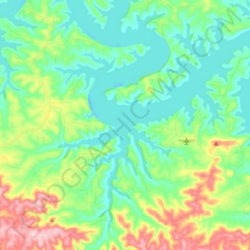
Название: Топографическая карта Bull Shoals Lake, высота, рельеф.
Местонахождение: Bull Shoals Lake, County Road 141, Midway, Marion County, Arkansas, 72661, United States of America (36.37527 -92.76475 36.46980 -92.62843)
Средняя высота: 246 м
Минимальная высота: 189 м
Максимальная высота: 390 м