
Топографическая карта Windermere
Интерактивная карта
Нажмите на карту, чтобы отобразить высоту.
Об этой карте
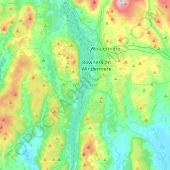
Название: Топографическая карта Windermere, высота, рельеф.
Местонахождение: Windermere, Bowness-on-Windermere, South Lakeland, Cumbria, England, United Kingdom (54.27457 -2.98175 54.42112 -2.92037)
Средняя высота: 132 м
Минимальная высота: 3 м
Максимальная высота: 478 м
There is debate as to whether the stretch of water between Newby Bridge and Lakeside at the southern end of the lake should be considered part of Windermere, or a navigable stretch of the River Leven. This affects the stated length of the lake, which is 11.23 miles (18.07 km) long if measured from the bridge at Newby Bridge,[10] or 10.5 miles (16.9 km) if measured from Lakeside[citation needed]. The lake varies in width up to a maximum of 1 mile (1.6 km), and covers an area of 14.73 km2 (5.69 sq mi).[10] With a maximum depth of 66.7 m (219 ft) and an elevation above sea level of 39 m (128 ft), the lowest point of the lake bed is well below sea level.[10]
Другие топографические карты
Нажмите на карту, чтобы просмотреть ее топографию, ее высоту и ее рельеф.
Storrs
United Kingdom > England > Cumbria > South Lakeland > Bowness-on-Windermere
Storrs, Windermere, Bowness-on-Windermere, South Lakeland, Cumbria, England, LA23 3QR, United Kingdom
Средняя высота: 93 м