
Сделать пожертвование
Топографическая карта Aviemore
Нажмите на карту, чтобы отобразить высоту.
Сделать пожертвование
Об этой карте
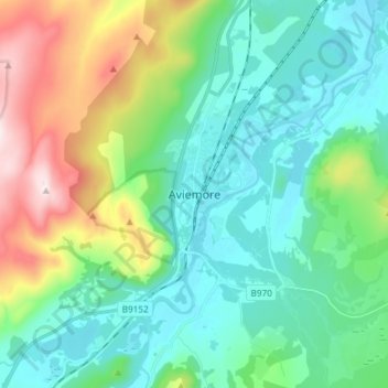
Название: Топографическая карта Aviemore, высота, рельеф.
Местонахождение: Aviemore, Highland, Scotland, PH22 1RN, United Kingdom (57.15375 -3.86875 57.23375 -3.78875)
Средняя высота: 331 м
Минимальная высота: 199 м
Максимальная высота: 711 м
Сделать пожертвование
Другие топографические карты
Нажмите на карту, чтобы просмотреть ее топографию, ее высоту и ее рельеф.
Skye
United Kingdom > Scotland > Highland
Beyond Loch Snizort to the west of Trotternish is the Waternish peninsula, which ends in Ardmore Point's double rock arch. Duirinish peninsula is separated from Waternish by Loch Dunvegan, which contains the island of Isay. It is ringed by sea cliffs that reach 296 metres (971 feet) on the west at Waterstein…
Средняя высота: 63 м
Сделать пожертвование
Сделать пожертвование
Invergarry Castle
United Kingdom > Scotland > Highland > Invergarry
The survey drawing shows a plan and elevations of the castle, called the 'Castle of Glangary' on the drawing. The drawing may appear misleading, as more than one facade is joined together, but by cross-referencing the lettering on the plan to the elevations the appearance can be judged.
Средняя высота: 150 м
Сделать пожертвование
Сделать пожертвование
Сделать пожертвование
Skye
United Kingdom > Scotland > Highland
Beyond Loch Snizort to the west of Trotternish is the Waternish peninsula, which ends in Ardmore Point's double rock arch. Duirinish peninsula is separated from Waternish by Loch Dunvegan, which contains the island of Isay. It is ringed by sea cliffs that reach 296 metres (971 feet) on the west at Waterstein…
Средняя высота: 63 м
Сделать пожертвование
Сделать пожертвование
Ardnamurchan
United Kingdom > Scotland > Highland
The north western corner of Ardnamurchan consists of a lopolith (previously interpreted as a ring dyke) that has been exposed at the surface. Evidence for such a structure can be identified from the phenocrysts in the rock exposures around the area of interest which show plagioclase crystals aligned towards…
Средняя высота: 73 м
Сделать пожертвование
Сделать пожертвование
Сделать пожертвование
Skye
United Kingdom > Scotland > Highland
Beyond Loch Snizort to the west of Trotternish is the Waternish peninsula, which ends in Ardmore Point's double rock arch. Duirinish peninsula is separated from Waternish by Loch Dunvegan, which contains the island of Isay. It is ringed by sea cliffs that reach 296 metres (971 feet) on the west at Waterstein…
Средняя высота: 63 м
Сделать пожертвование
Сделать пожертвование
Сделать пожертвование
Сделать пожертвование
Сделать пожертвование
Сделать пожертвование
Сделать пожертвование
Сделать пожертвование
Сделать пожертвование
Loch Affric
United Kingdom > Scotland > Highland
A number of smaller lochs surround Loch Affric. At the southwestern end sits Loch Coulavie located at the base An Tudair Beag and a slightly higher elevation. Also, at the southwestern end, the river Affric flows into the tiny loch of Loch na Camaig. At the northeastern side, Loch Pollan Fearna drains into…
Средняя высота: 477 м
Сделать пожертвование
Isle of Rum
United Kingdom > Scotland > Highland > Kinloch
The island's relief is spectacular, a 19th-century commentator remarking that "the interior is one heap of rude mountains, scarcely possessing an acre of level land". This combination of geology and topography make for less than ideal agricultural conditions, and it is doubtful that more than one tenth of the…
Средняя высота: 118 м
Сделать пожертвование
Сделать пожертвование
Сделать пожертвование
Loch Morar
United Kingdom > Scotland > Highland > Morar
Loch Morar (Scottish Gaelic: Loch Mòrair) is a freshwater loch in Lochaber, Highland, Scotland. It is the fifth-largest loch by surface area in Scotland, at 26.7 km2 (10.3 sq mi), and the deepest freshwater body in the British Isles with a maximum depth of 310 m (1,017 ft). The loch was created by glacial…
Средняя высота: 118 м
Сделать пожертвование
Сделать пожертвование