
Спасибо за поддержку этого сайта ❤️
Сделать пожертвование
Сделать пожертвование
Топографическая карта Найнитал
Нажмите на карту, чтобы отобразить высоту.
Спасибо за поддержку этого сайта ❤️
Сделать пожертвование
Сделать пожертвование
Найнитал
Город расположен в предгорье Гималаев на высоте около 2 000 м над уровнем моря в глубокой долине около озера. Город окружают несколько гор, из которых самые высокие — Найна (2 615 м) на севере, Деопатха (2 438 м) на западе и Аярпатха (2 278 м) на юге.
Спасибо за поддержку этого сайта ❤️
Сделать пожертвование
Сделать пожертвование
Об этой карте
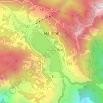
Название: Топографическая карта Найнитал, высота, рельеф.
Местонахождение: Найнитал, Nainital, Уттаракханд, 263003, Индия (29.37263 79.43883 29.39879 79.46999)
Средняя высота: 2 059 м
Минимальная высота: 1 562 м
Максимальная высота: 2 449 м
Спасибо за поддержку этого сайта ❤️
Сделать пожертвование
Сделать пожертвование