
Сделать пожертвование
Топографическая карта Encinitas
Нажмите на карту, чтобы отобразить высоту.
Сделать пожертвование
Encinitas
Encinitas lies on a rugged coastal terrace. The city is bisected by a low-lying coastal ridge that separates New and Old Encinitas. In the north of the city, the coast rises in elevation and the land is raised up in the form of many coastal bluffs, which are subject to collapsing on the narrow beach. The city is bounded by Batiquitos Lagoon to the north and San Elijo Lagoon to the south.
Сделать пожертвование
Об этой карте
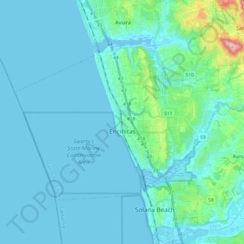
Название: Топографическая карта Encinitas, высота, рельеф.
Местонахождение: Encinitas, California, United States (32.99599 -117.36829 33.08897 -117.19570)
Средняя высота: 32 м
Минимальная высота: -1 м
Максимальная высота: 317 м
Сделать пожертвование
Другие топографические карты
Нажмите на карту, чтобы просмотреть ее топографию, ее высоту и ее рельеф.
Mount Shasta
United States > California > Siskiyou County
Mount Shasta (/ˈʃæstə/ SHASS-tə; Shasta: Waka-nunee-Tuki-wuki; Karuk: Úytaahkoo) is a potentially active stratovolcano at the southern end of the Cascade Range in Siskiyou County, California. At an elevation of 14,179 ft (4,322 m), it is the second-highest peak in the Cascades and the fifth-highest in…
Средняя высота: 3 717 м
Сделать пожертвование
Elk Creek
United States > California > Glenn County > Elk Creek
Elk Creek is a census-designated place in Glenn County, California. It is located 19 miles (31 km) northwest of Willows, at an elevation of 745 feet (227 m).
Средняя высота: 258 м