
Спасибо за поддержку этого сайта ❤️
Сделать пожертвование
Сделать пожертвование
Топографическая карта Ashburn
Нажмите на карту, чтобы отобразить высоту.
Спасибо за поддержку этого сайта ❤️
Сделать пожертвование
Сделать пожертвование
Ashburn
Ашберн расположен на средней высоте 90 м над уровнем моря. По данным на переписи 2010 года, статистически обособленная местность (CDP) имеет общую площадь 44,77 км², из которых 44,09 км² земли. Ашберн расположен между Вашингтонским аэропортом имени Даллеса и городом Лисберг.
Спасибо за поддержку этого сайта ❤️
Сделать пожертвование
Сделать пожертвование
Об этой карте
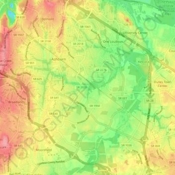
Название: Топографическая карта Ashburn, высота, рельеф.
Местонахождение: Ashburn, Loudoun County, Виргиния, Соединённые Штаты Америки (38.98828 -77.52279 39.07175 -77.43142)
Средняя высота: 85 м
Минимальная высота: 36 м
Максимальная высота: 131 м
Спасибо за поддержку этого сайта ❤️
Сделать пожертвование
Сделать пожертвование